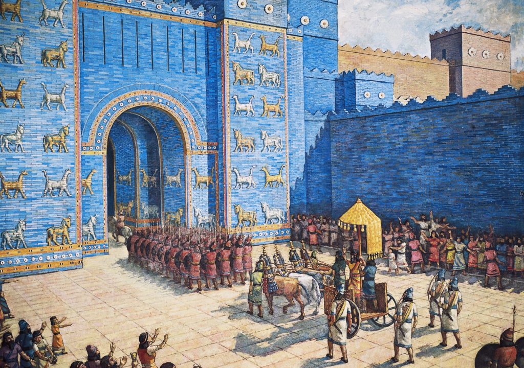
 Was Noah a biblical character? The Younger Dryas sea level rise is a historical event in early earth history and could be the great flood.
At the end of the last ice age, 12 000 years ago, the earth was moving out of a glacial maximum. More than six billion cubic meters of glacial ice covered the face of the planet compared to today. Most of it was situated over the North American Ice Cap.
For many years, geologists accepted the gradual ice-dam burst theory as an explanation for the transition. Now a period known as the ‘Younger Dryas’ reveals a swifter increase in global sea levels.
Ancient societies have long told of a great flood story that pre-empted modern times.
New geological evidence etched in the land itself is suggesting catastrophic events in early earth history that could be more than myth. The Younger Dryas sea level rise remains a profound mystery in the human story.
The great flood ‘myth’ and early earth history
The biblical flood in the book of Genesis is one of the most widely known human stories. Noah was ordered to build an ark to protect himself, his family, and animals from the rising flood waters.
It’s lesser known that the bible is one of the hundreds of prehistoric and global flood accounts.
Ancient Greece had its version where Deucalion and his wife, Pyrrha, prepared for the great flood by building an ark.
Stories are found throughout almost all cultures in the ancient world.
The Sumerian counterpart to Noah was called Zisuthrus, whose tale of the great flood preceded the biblical account by over a thousand years.
There are stories of great floods and world-changing events across the Americas. The Aztec, Inca, and Maya Civilizations all describe an ancient deluge.
In Australia, the Pacific Islands, and New Zealand, there are accounts of ancient mega-tsunamis.
There are literally hundreds of accounts of global floods found across the planet.
These stories are often dismissed as localized memories of small events. Today, the evidence is mounting for a global flood that caused sea levels to rise at the end of the last ice age.
The end of the ice age and the great flood
About 12 000 years ago, the earth moved out of its last glacial maximum. It was a period where 6 billion cubic meters of ice needed to be distributed across the planet. The timeframe is now known as the Younger Dryas, when the earth was thrown back into a mini ice age for 1200 years. Once the cold-snap ended, there was rapid global warming and rising sea levels.
One point that has baffled scientists is how quickly the ice disappeared. To melt such a vast volume of glacial ice, it would take tens of thousands of years.
Geologists have discovered that it vanished 4000 years. That is a blink of an eye-lid in early earth history.
While disappearing quickly, the volumes of water to be moved are mind-boggling. Estimates across North America show geological scars require flows at 752,000,000 cubic feet per second.
This number is huge. Beyond huge. Almost unthinkable. It is ten times greater than all the combined rivers flowing on earth today.
The most widely held hypothesis to explain where the water went is the ice-dam burst model. It describes a gradual bursting process of ice dams on top of the ice sheets.
For this to happen, the water held by the hypothetical ice dam would have been 2100 feet deep and spanning hundreds of miles on top of the ice.
It would have held over 500 cubic miles of water a thousand times larger than any modern ice dam burst ever seen.
The highest modern dam in North America is around 700 feet deep. The proposed ice dam would have needed to span 7 miles wide at its highest point, and 2 miles wide at its base.
Evidence of the great flood
During the Younger Dryas sea level rise, North America was ground zero as the ice sheets melted. It took the full force of the breaking flood waters. Across the continent are the scarred landscapes that fossilize the memories of the enormous floods.
When the floodwaters tore across the continent, they carved out giant river valleys; ground down basalt bedrock, and carried some of the world’s largest boulders, leaving them erratically scattered in it’s wake.
Below are some examples of the destruction the floodwater caused as it poured off the ice sheet.
Thousands of square miles of vegetation were completely washed away as well as intense amounts of soil and sediment. As a result, the area known as the ‘Channeled Scablands’ in Eastern Washington was created, pictured below.
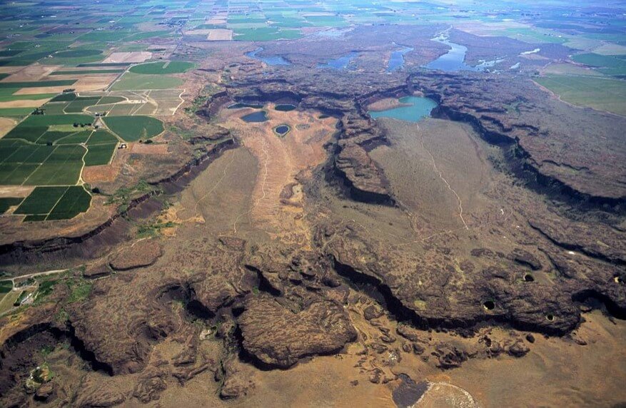
The Channeled Scablands
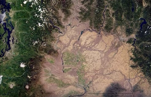
The Channeled Scablands in Eastern Washington.
Dry Falls
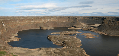
Dry Falls North Eastern Washington
North Eastern Washington is home to extreme geological landscapes that tell of a cataclysmic past. Dry falls is one of the countless examples etched into the land. The amount of water once flowing through the extinct cataract is mind-boggling.
The cliffs in the above image are 600 feet high in places. (Niagara Falls is only 165 feet high). Not only that, Dry Falls is 3.5 miles wide which is (two miles wider than Niagara).
Calculations of water mass to create Dry Falls paint the picture of a giant flood. The channels observed at Dry Falls are immensely steep yet the ancient river pathways leading to and from the falls are relatively straight. The required water indicate immense flows responsible for the leaving the landscape.
Camas Prairie Current Ripples
Camas Prairie Current Ripples
Littering the scabland region are areas of landscape known as ‘current ripples.’ They are created by a natural process seen on a much smaller scale on beaches and riverbeds. The ripples form from water flowing across the land, however, the sizes of the ripples that are found in North America are the largest found on the planet.
There are now over 100 documented areas that contain these huge ripples that formed as the floodwaters flowed across North America. Camas Prairie is home to some of the largest with some up to 50 feet high and spaced almost 500 feet apart.
The water flow to create such large ripples is almost unimaginable. To form a ripple this big, a massive flow of water needs to happen in a brief amount of time. It is estimated that the erosion rate would be around one billion cubic feet of bedrock per day.
Potholes Cataract
Potholes Cataract, Dry Falls Washington.
Potholes Cataract is another jaw-dropping geological feature carved out by the floodwaters. The extinct cataract has a similar horseshoe-shaped appearance to Niagara Falls, however, was carved out in a matter of days.
The water is thought to have been over 400 feet deep. As it flowed it scraped out the 850 foot deep chunks of bedrock to leave behind the scarred landscape in the above image. This particular cataract spans 5 miles across and is one of the hundreds of examples of catastrophic flooding in North America.
While the evidence for the great flood is mainly located in North America, there are similar patterns all over the world at the end of the last ice age.
North Africa, Australia, Siberia, Mongolia, parts of the Middle East, Much of South America as well as Northern Europe are among the places that show evidence of mega-scale flooding that occurred around the time the ice sheets over North America melted.
Conclusion:
Ancient societies all over the planet report stories similar to the Bible story of Noah’s flood. Recently the understanding of the end of the last ice age has helped to reveal the possibility of an actual flood event occurring.
During the Younger Dryas sea levels rise, an immense amount of water needed to be distributed across the planet. The enormous scale and flow of water that swept across the globe as the North American ice sheet melted is unlike anything seen in modern times.
It is hard to comprehend the magnitude of the geological features left behind, and even harder to imagine the power of the seemingly impossible amount of water that created them.
Now it’s up to you.
Is early earth history dotted by floods and sea level rise? Or, do they remain the realms of myth and story?
Leave your thoughts in the comment section below.
References:
- Allen, J. E., Burns, M., Sargent, S. C., Cataclysms on The Columbia, Timber Press, (1986)
- https://pubs.geoscienceworld.org/gsa/gsabulletin/article-abstract/53/11/1569/3899/unusual-currents-in-glacial-lake-missoula-montana